
This technology is key to optimising forest management strategies, monitoring greenhouse gas emissions and contributing to climate change mitigation”
The ESA Earth Explorer Biomass missions and those of the Copernicus Sentinel-5, Sentinel-1D, and Sentinel-3D programmes exemplify the synergy between science, technology, and industry in our country, where Spain’s involvement, and in particular the involvement of TEDAE member companies, is essential to achieving their objectives.
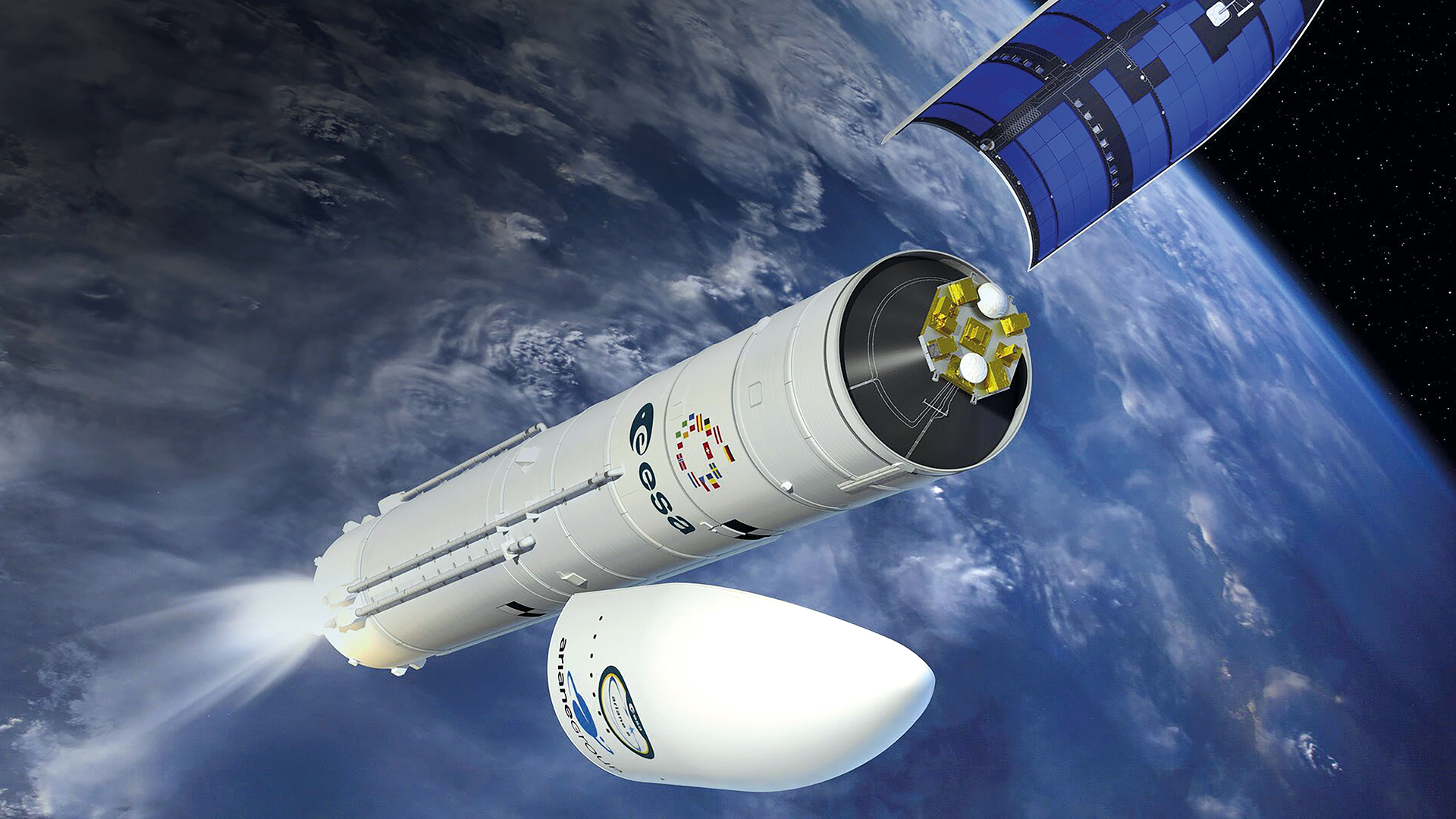
Sentinel-5: atmospheric watchdog for the environment
The Copernicus programme is synonymous with Earth observation and monitoring, and the Sentinel-5 mission sits at the heart of this ambitious project. Dedicated to observing atmospheric composition, Sentinel-5’s primary mission is to track trace gases and pollutants that affect air quality.
The high precision of the instruments on board Sentinel-5 allows for the identification and quantification of atmospheric pollution episodes, facilitating decision-making at both regional and global levels. This mission’s capacity for continuous and systematic monitoring of the European atmosphere makes it an indispensable tool for tackling environmental and sustainability challenges.
In the case of Sentinel-5, the role of Spanish industry is pivotal. Indra and GMV have developed data processing systems and analysis solutions that transform the vast amount of collected information into useful data for scientists and policymakers.
Similarly, Sener has participated in the integration of instrumental systems, while Elecnor Deimos has contributed to the management of the ground segment and the design of secure and efficient communication infrastructures. Thanks to these contributions, Spain not only strengthens its image as a leading technological player but also drives the advancement of European atmospheric science.
Airbus Defence and Space España maintains a key role in this mission, drawing on experience from the Sentinel-5 Precursor launched in 2017. The company has optimised the thermal control and calibration systems of the TROPOMI instrument, essential for maintaining the accuracy of measurements throughout the satellite’s lifespan.
The mission will generate one terabyte of information daily, available free of charge to governments and scientific institutions. Kevin McMullan, the ESA project manager, emphasises that “this data transparency will drive evidence-based policies to improve air quality in urban and industrial areas”.
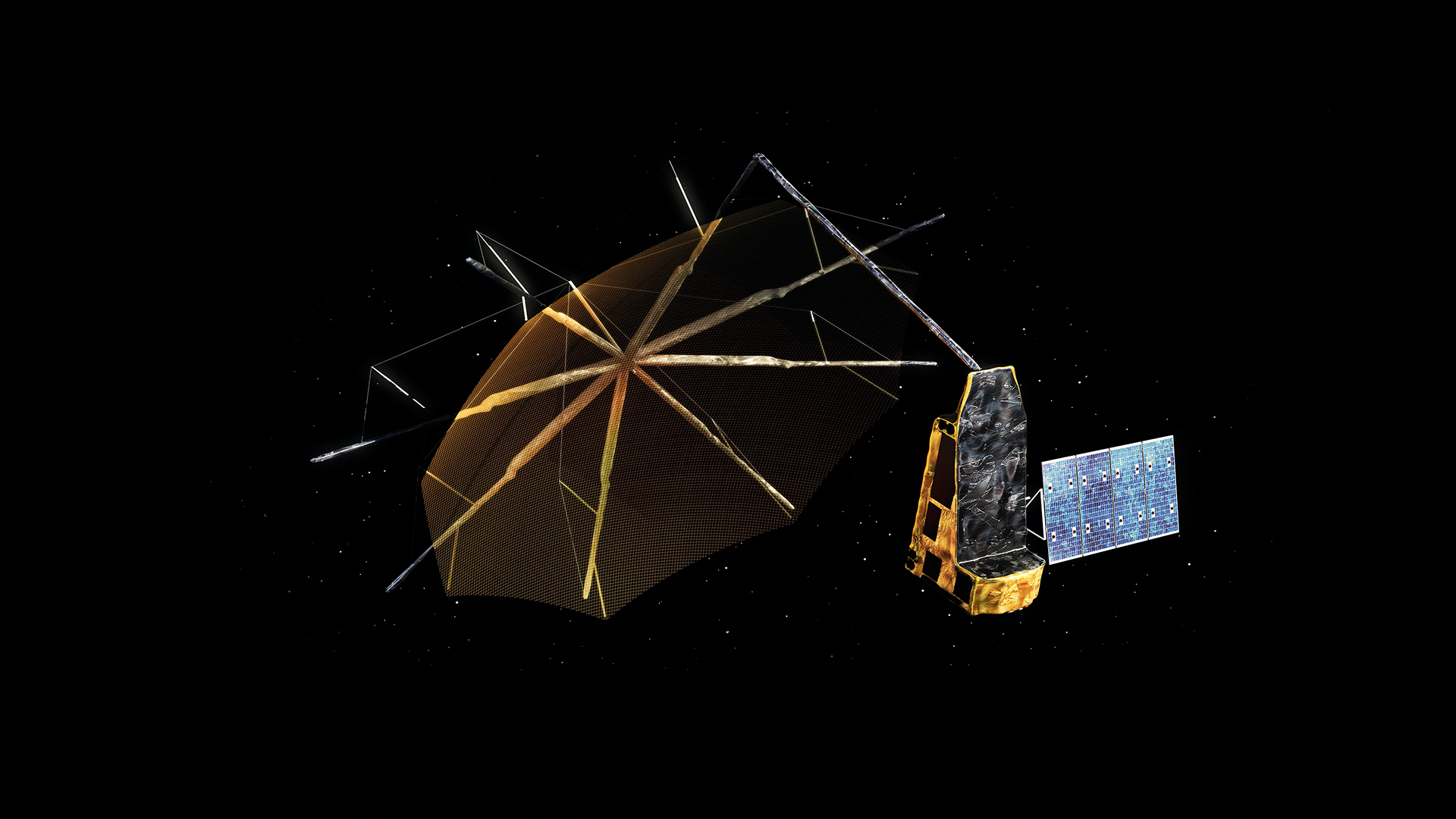
ESA Earth Explorer Biomass: eyes on our forests
The Biomass mission, part of ESA’s Earth Explorer programme, aims to estimate and map forest biomass content on a global scale.
It will prove invaluable in helping us understand the carbon cycle and assess the health of forest ecosystems. Thanks to its ability to penetrate the forest canopy, the instrument will measure the internal structure of woodlands and quantify biomass with unprecedented accuracy.
Among the companies participating in Biomass is GMV, which has lent its expertise in data processing and algorithm development. For its part, Sener has contributed to the design of the platform and the integration of complex systems, as well as the deployment mechanism for the 12-metre reflector, crucial for capturing high-precision radar signals.
Airbus Defence and Space España has spearheaded the satellite’s thermal control, designing and manufacturing components such as heat pipes and thermal blankets that ensure operational stability in orbit.
Meanwhile, Indra and Elecnor Deimos have participated in the coordination of the command chain and in the commissioning of the ground segment, ensuring that the mission benefits from cutting-edge technologies and impeccable operational management. These companies, members of TEDAE, represent Spain’s commitment to innovation and technological excellence. Their collaboration, which involves more than 50 companies from 20 countries, exemplifies the Spanish capacity to integrate into international consortia of high technological level.
Vega-C will place Smile in a low Earth orbit, from which the spacecraft will propel itself to a high Earth orbit”
Sentinel-1D: a revolution in radar-based Earth observation
The Sentinel-1 mission, in its various guises, has revolutionised the way we monitor the Earth’s surface. The new version, Sentinel-1D, is poised to be an evolution of this successful series, incorporating improvements in resolution, coverage, and real-time processing capability. This mission focuses on Earth observation using radar technology, enabling constant monitoring of phenomena such as land deformation, glacier evolution, and the dynamics of urban and agricultural landscapes.
Sentinel-1D’s radar is particularly useful for detecting changes in environments that are difficult to observe using optical sensors, since it can operate in darkness and in the presence of cloud cover. This enables continuous tracking of natural and anthropogenic processes, making it an indispensable ally for natural disaster management and territorial planning.
Spain’s participation in Sentinel-1D reaffirms the country’s leadership in the field of radar and remote sensing. Companies such as Sener and GMV have collaborated closely on the development of software and algorithms that allow radar signals to be interpreted with great precision. Indra has contributed its expertise in control and monitoring systems, while Elecnor Deimos has contributed to the design and validation of critical system components.
They have been instrumental in ensuring that the mission has the technical capabilities necessary to operate in complex and demanding environments. Thales Alenia Space España acts as the prime contractor for the TT&C (Tracking, Telemetry and Command) communications subsystem, and the Spanish contribution extends to companies such as ARQUIMEA, responsible for the thermal control systems for the laser communication terminal, and ALTER, which validated the electronic components’ resistance against cosmic radiation. This multidisciplinary approach ensures that Sentinel-1D maintains global coverage every 6 days, an invaluable resource for managing crises such as floods or volcanic eruptions.
Vega C: smile mission
Following the successful launch of Sentinel 1-C in December 2024, a new mission for the Vega-C rocket is scheduled for late 2025 from French Guiana. This time, the launcher will place the Smile (Solar Wind Magnetosphere Ionosphere Link Explorer) satellite into orbit, a collaboration between the European Space Agency (ESA) and the Chinese Academy of Sciences (CAS).
Smile, the first scientific space mission that ESA and China have jointly selected, designed and developed, and will jointly launch and operate, aims to study the interaction between the Sun and the Earth.
Vega-C will place Smile in a low Earth orbit, from which the spacecraft will propel itself to a high Earth orbit. In this final, egg-shaped orbit, Smile will orbit the Earth approximately every two days.
It will move about 121,000 km away from the Earth’s surface to observe the northern polar regions for longer periods. This will allow it to observe regions of space near Earth for more than 40 hours at a time.
It will examine for the first time in video and X-ray images how the solar wind collides with the Earth’s protective magnetic bubble. Thanks to its complementary ultraviolet images, the longest ever continuous observation of the aurora borealis will be obtained. Its orbit then allows it to approach within 5,000 km to download the collected data to ground stations in Antarctica and China.
El Programa Ariane 6: a new horizon for Europe
For decades, Europe has led the space launch market thanks to its Ariane 4 and, especially, Ariane 5 launchers, which, with their ability to perform double satellite launches, cemented European supremacy in space
On 5 July 2023, Ariane 5 carried out its last mission, marking the end of an era. However, the transition to Ariane 6 has been slower than expected, and various delays have postponed its debut until 2024.
Currently, the Ariane 6 Programme is progressing towards its full deployment. The maiden flight of Ariane 6 took place on 9 July 2024, flight VA262, which was successful and carried different payloads on board.
The first commercial flight of Ariane 6, VA263, took place on 6 March 2025, again from Kourou, in which the CSO-3 communications satellite was successfully placed into orbit. The second commercial flight of Ariane 6 is scheduled in the coming months, during 2025.
Autonomy and sovereignty in launch capabilities are crucial for Europe. Ariane 6, with its modular design, and versions 62 and 64 for 2 and 4 solid rocket boosters respectively, can launch payloads of up to 20,000 kg into low Earth orbit.
This capability, along with flexibility and efficiency, are vital to ensuring that Europe can carry out space missions without relying on other countries.
Competition in the space sector is now fierce, and Europe must stay at the forefront to avoid losing its strategic position, and must do so quickly.
In addition, micro-launchers, capable of placing satellites into orbit covering a wide range of masses depending on the different orbits, are emerging as a complementary solution within the European portfolio, being essential to guaranteeing Europe’s independence in access to space.
The Ariane 6 Programme, together with micro-launchers, represents the future for access to space in Europe with autonomy, both in institutional and commercial missions, and will significantly boost the industrial and technological growth of the space sector in Europe. This advance will not only strengthen the European economy, but will also allow Europe to consolidate its strategic position in the space field worldwide.
The maiden flight of Ariane 6 took place on 9 July 2024, flight VA262, which was successful and carried different payloads on board”
LEOPNT-IoD (LEGION) – Pathfinder A: a next-gen mission
Global Navigation Satellite Systems (GNSS) play a crucial role in providing positioning, navigation and timing (PNT) services. However, there are still a number of cases where their performance needs improvement. These include operation in indoor environments, where they suffer radio frequency interference, as well as the reduction of the convergence time to a centimetre-level accuracy.
To this end, the European Space Agency has launched the LEO-PNT IoD (In-Orbit Demonstrator) mission, also known as LEGION.
This mission consists of a system of 10 satellites that will fly in low Earth orbit to test innovative signals in various frequency bands. In this way, it will evaluate how a LEO fleet can operate in combination with Galileo, EGNOS and other GNSS under a multi-layered approach to increase the overall resilience and robustness of PNT systems and thus enable new solutions.
As part of this mission, a pair of CubeSats (Pathfinder A satellites) are scheduled to be launched at the end of 2025 into a quasi-polar orbit at an altitude of 550 km to reduce the risk of critical technologies and the implementation of the payload, as well as of user test receivers and the ground control segment, and to carry out the first experiments that do not need more than one satellite.
Next, a set of 4 satellites (the Pathfinder B) will be launched to have a mini-constellation deployed by 2027. The results obtained with this limited number of satellites can then be extrapolated by means of simulations to evaluate the performance achievable with a complete constellation.
LEO-PNT IoD is part of ESA’s FutureNAV programme, which seeks to keep Europe at the forefront of satellite navigation.
Programa SPAINSAT NG: a new generation of satellites
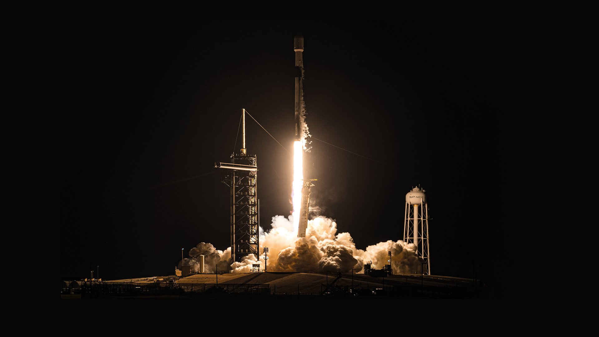
On January 29th, Spain took a giant leap in its spacefaring history with the launch of SpainSat NG I aboard a SpaceX Falcon 9 rocket, heralding a new era for secure and defence-focused communications.
This launch marked the opening chapter of an ambitious space programme, championed by the Ministry of Defence and Hisdesat, that will culminate next autumn with the launch of SpainSat NG II, its twin satellite.
Experts are calling this programme a “revolution in military communications”, the result of over 15 years of development and of particular significance given the current climate of geopolitical instability, where strategic autonomy is key.
Indeed, with the SpainSat NG satellites, Spain secures its governmental communications with maximum security and resilience, bolstering its technological sovereignty and its role in global security.
Their entry into service will improve Spain’s response capability to emergencies, humanitarian missions, and critical security and defence operations. The Spanish Armed Forces and government agencies will be the primary users, but the SpainSat NGs will also serve allied nations and international institutions like NATO and the European Commission.
The SpainSat NGs usher in a new generation of satellites, boasting active X-band antennas, advanced systems to protect against interference and cyberattacks, and coverage spanning Europe, the Americas, and the Middle East – a technological leap of unprecedented scale.
The project isn’t just a strategic advance. It’s also been a growth engine for Spain’s space industry, thanks to Hisdesat’s role as a trailblazing company in the sector. Spanish industry has contributed 45% of the SpainSat NG development, driving innovation with over 2,000 engineers working on the project.
Another key element of the programme is the Hisdesat Satellite Control Centre, located in Hoyo de Manzanares near Madrid. From these facilities, among the most modern and technologically advanced in Europe, this ambitious space programme will be operated and monitored.
Sentinel-3D: a more complete picture of our planet
Sentinel-3 has traditionally been a mission focused on monitoring Earth’s land and ocean surfaces, providing data on temperature, water composition and vegetation. The 3D variant, expected to launch in 2025, takes this capability to the next level, integrating a novel approach to obtain more complete and precise representations of the planet.
This upgrade aims to improve our understanding of Earth’s dynamic processes, from climate change to the evolution of marine and terrestrial ecosystems. The innovation in Sentinel-3D lies in the combination of multiple sensors and the integration of advanced image processing techniques, making it possible to generate maps of unprecedented quality.
These maps will be an essential tool for urban planning, natural resource management, and emergency response, allowing comprehensive visualisation of changes on land and sea.
Spanish industry has once again made a vital contribution. Companies like GMV have spearheaded the development of 3D reconstruction algorithms and data analysis, while Sener and Indra have collaborated on the integration of instrumental systems and optimisation of the satellite’s architecture.
Elecnor Deimos, meanwhile, has handled the development of the ground segment and reception/processing infrastructure, ensuring the data generated by Sentinel-3D can be efficiently distributed to end-users.
Thales Alenia Space España is involved in integrating the Ocean and Land Colour Instrument (OLCI), capable of distinguishing 21 spectral bands for analysing phytoplankton and chlorophyll. Airbus España is contributing algorithms for thermal data processing.
This collaboration of leading tech firms strengthens Spain’s ability to innovate and lead highly complex space projects. This satellite inherits the legacy of Sentinel-3B, whose data has already improved EU agricultural performance forecasts by 30%, according to the European Commission. With an estimated lifespan of seven years, the 3D version will ensure the continuation of these services until at least 2032.
METOP-SG and Advanced Weather Observation
The METOP (Meteorological Operational satellite) Programme began in 2006 with the launch of METOP-A, Europe’s first polar-orbiting meteorological satellite. Developed by the European Space Agency (ESA) and the European Organisation for the Exploitation of Meteorological Satellites (EUMETSAT), it has been instrumental in improving weather forecasts and climate monitoring.
The second generation, METOP-SG (Second Generation), represents a significant advance in meteorological observation technology. The programme comprises six satellites divided into two series: METOP-SG-A and METOP-SG-B. Each series includes three satellites operating in pairs. The A satellites are equipped with instruments such as the IASI-NG (infrared sounder) and the METimage (multispectral imager), while the B satellites include the SCA (scatterometer) and the MWI (microwave imager).
METOP-SG, along with data from the innovative European instruments onboard, will feed into forecasting models, improving the accuracy and resolution of measurements and enabling more detailed monitoring of critical physical variables. These advanced capabilities are essential for numerical weather prediction, particularly in polar regions where geostationary satellite coverage is limited.
The benefits of METOP-SG are far-reaching, impacting areas such as agriculture, disaster management, and maritime navigation, demonstrating its vital added value for society and the return on investment in space technology.
It is important to highlight the complementary relationship between the METOP-SG Programme, which operates in polar orbit, providing global coverage and high revisit capability, and MTG (Meteosat Third Generation), which operates in geostationary orbit, offering continuous surveillance of specific areas. The combination of data from both types of satellites maximises the accuracy and effectiveness of weather forecasts, benefiting society with invaluable information. Furthermore, thanks to international cooperation with similar missions, there are benefits and synergies between Europe and other countries, such as the USA.
The first satellite in this new constellation, METOP-SG-A1, is scheduled to launch aboard the Ariane 6 in the coming months during 2025, circling the Earth from pole to pole in roughly 50 minutes. This satellite will be much closer to Earth than a geostationary satellite, which orbits at an altitude of 35,786 km. METOP-SG-A1 will operate at an altitude of 832 km, enabling it to achieve global coverage with more than 10 passes a day and make more detailed and accurate observations.
The benefits of METOP-SG are far-reaching, impacting areas such as agriculture, disaster management, and maritime navigation”


